TOWN OF TWO RIVERS


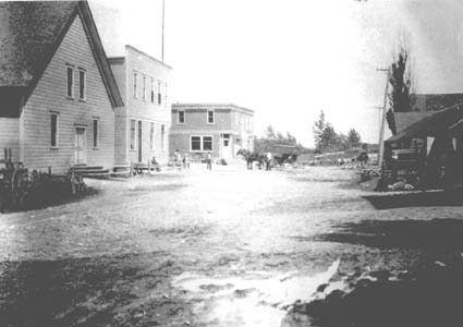 Shoto 1912
What's in a Name??????
Shoto
It's been called "Nijode" by the Ojibwa's, "Nisho-ta" and "Nichote" by the
Potawatomi's,"Nisiwan" by the Menominee's, and "Neshota" by the Chippewa's.
No matter who lays claim to naming our town, they all mean the same;
"twin". Of course, they are referring to the West Twin River, or Neshota
River that flows through our town. The upper course of the river originates
in Brown County, and it still is called Neshota River. It is joined in
Brown County with King Creek at the Neshota Park. The river travels
southeastward into Manitowoc County where it becomes the West Twin River
and flows as such until it meets it's sister river, the East Twin River,
in Two Rivers, and empties into Lake Michigan.
Indians
The Indians in our area were Menominee's, Ottawa's, Chippewa's,
Winnebagoe's and Potowatomee's. When the Treaty of 1831 was signed with
the Menominee's, 21/2 million acres, including our township, was turned
over to the United States government. The treaty was with the Menominee's
because they were looked upon as the real owners of the land, yet the
Potowatomee's laid claim to the territory until released by treaty in 1833.
A land office was established in Green Bay, and a survey was completed by
the summer of 1835. A fee of 48 cent to 1.25 per acre was set, and the
land was thrown open to settlers. Neshoto was marked on the map as: 8
miles west from the mouth of the West Twin River. When the white settlers
appeared here, the Indians they met were peaceful, living in bands along
the river. In the summer they lived along the river because of the readily
access to fish and for the rich soil for planting corn, pumpkins, squash,
beans and potatoes. They also tapped the sugar maple trees for making
maple sugar. In the winter, they moved deeper into the woods not only for
protection from the harsh Wisconsin weather, but because small and larger
game was more abundant. Deer and bears were hunted for the skins and meat.
The Indians lived in rounded huts constructed from saplings covered with
bark. They traded with the white settlers venison and berries for pork and
bread.
They moved these huts in spring and fall. Each family had their own tract
of land while they lived in bands. Squaws were in charge of not only
taking care of the family, but also of the crops they planted. They would
also trade buckskin, beadwork or woven baskets for a few seed potatoes.
The Indians knew no English, and the settlers knew no Indian. They
communicated with a form of sign language. The only Indian in our area
that spoke English was "Katoose." He seemed to understand the settlers
fear of Indians, and made every effort to ease their fears when in their
company. He said his white man name was John Williams, but he never told
of his past, nor where he was educated. Some settlers called him John
Buttons because of the belt he wore was studded with large and flat brass
buttons.
Various Indian artifacts have been found throughout our township. Many
were donated to the museums in our area. It is rumored that there was an
Indian burial ground on "top of the hill" in Shoto. We have found no
documentation to support that claim, however, records were not kept even
for the school until 1860. The Indians moved out of our area to the upper
Wolf River around 1870.
|